
. .
There are times when the most extraordinary things fall right onto my lap. I’ve been struggling to find a decent map of 17th century Paris — a detailed map that shows the names of the street.
I recently purchased an e-book collection (Paris: An Electronic Tour of the Old City by Robert W. Berger) that promised to have maps. Although the collection is fantastic, with visuals of Paris I’m thrilled to have in hand as well as a number of other documents, the maps were too general for my use, and I couldn’t zoom in on them.

Today, historian Holly Tucker sent me this link to a page put together by the Kyoto University Library: click here.
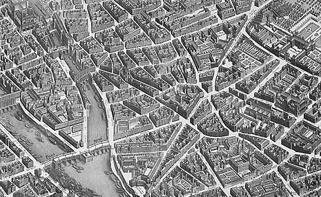
Mon Dieu! For here was the map I’d been searching for. It was made in 1739, but that’s close enough. I can zoom in to my heart’s content, and the streets are all labeled.
Another document in the collection provides a map of 1684. It’s more general, but it helps give some idea of the changes.
One of the documents — one of several on this site — is a digital copy of a book describing Paris in 1684. I can turn the pages, enlarge the type.
I’m overwhelmed!

That is a great map of Paris. Although I'm not writing about Paris, I've stayed in the Marais many times over the years and love the Jours des Patrimoine in the fall when many old buildings are open to the public for the weekend. When in Paris, I also went into some French bookstores and bought books/maps identifying buildings in the Marais. Actually, I'm a bit crazy for maps, maybe because my father was a surveyor.
The book I'm working on now is set in 14th century Avignon. There are a lot of old maps of Avignon, but it's hard to figure out which streets and buildings existed in the first few decades of the century, since so much building took place in later decades.
Funny how these old maps never are oriented the way ours are–with north at the top. I wonder when mapmakers began doing that as a matter of course.
Thanks for all these interesting posts, Sandra. Gets us thinking!